File:NW Native Tribes, 1792.png
Jump to navigation
Jump to search
Size of this preview: 616 × 599 pixels. Other resolutions: 247 × 240 pixels | 493 × 480 pixels | 884 × 860 pixels.
Original file (884 × 860 pixels, file size: 153 KB, MIME type: image/png)
Captions
Captions
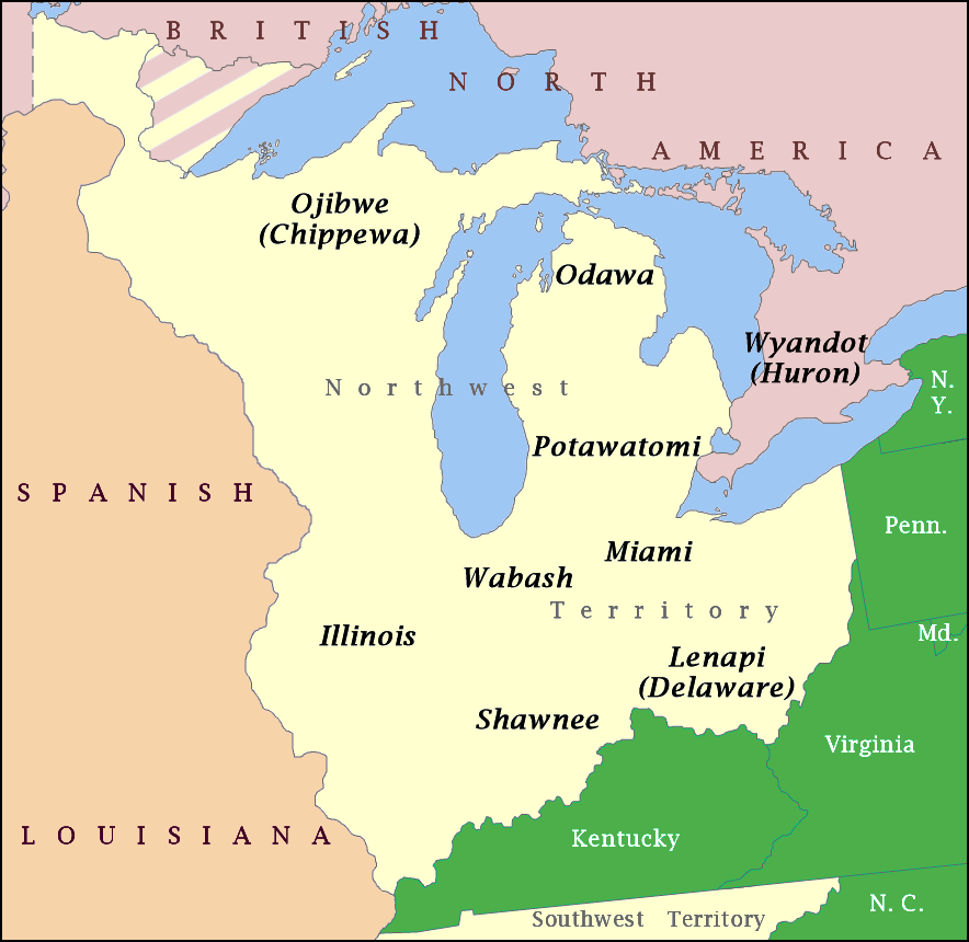
Native Tribes Located In The Northwest Territories of the United States - 1792

|
This historical map image could be re-created using vector graphics as an SVG file. This has several advantages; see Commons:Media for cleanup for more information. If an SVG form of this image is available, please upload it and afterwards replace this template with
{{vector version available|new image name}}.
It is recommended to name the SVG file “NW Native Tribes, 1792.svg”—then the template Vector version available (or Vva) does not need the new image name parameter. |
Summary
[edit]
| Description |
English: Map showing the general distribution of Native American tribes in the Northwest Territory at the time of the Northwest Indian War. |
| Date | |
| Source | Own work |
| Author | Drdpw |
Licensing
[edit]
I, the copyright holder of this work, hereby publish it under the following license:
This file is licensed under the Creative Commons Attribution-Share Alike 4.0 International license.
- You are free:
- to share – to copy, distribute and transmit the work
- to remix – to adapt the work
- Under the following conditions:
- attribution – You must give appropriate credit, provide a link to the license, and indicate if changes were made. You may do so in any reasonable manner, but not in any way that suggests the licensor endorses you or your use.
- share alike – If you remix, transform, or build upon the material, you must distribute your contributions under the same or compatible license as the original.
File history
Click on a date/time to view the file as it appeared at that time.
| Date/Time | Thumbnail | Dimensions | User | Comment | |
|---|---|---|---|---|---|
| current | 23:57, 11 October 2019 | | 884 × 860 (153 KB) | Hohum (talk | contribs) | More cartographic colour |
| 23:12, 4 April 2018 |  | 884 × 860 (706 KB) | Drdpw (talk | contribs) | User created page with UploadWizard |
You cannot overwrite this file.
File usage on Commons
There are no pages that use this file.
File usage on other wikis
The following other wikis use this file:
- Usage on ar.wikipedia.org
- Usage on cs.wikipedia.org
- Usage on en.wikipedia.org
- Usage on es.wikipedia.org
- Usage on id.wikipedia.org
- Usage on ko.wikipedia.org
- Usage on ru.wikipedia.org
- Usage on zh.wikipedia.org
Metadata
Categories:
- Maps of Native American tribal territories
- Maps of the Midwestern United States
- Maps of the Northwest Indian War
- Miami maps
- Lenape maps
- Northwest Territory
- 1780s maps of Ohio
- 1780s maps of Indiana
- 1780s maps of Michigan
- 1780s maps of Illinois
- 1780s maps of the United States
- Shawnee maps
- Ojibwa
- Odawa
- Huron
- Potawatomi
- Wabash Confederacy
- Maps showing 1792
- 1792 maps of the United States